Residential Township Architectural Model: Planning Roads, Buildings and Landscapes
A residential township is more than a group of buildings on a large site. It creates a complete living environment for residents. Roads, homes, parks, amenities and open spaces work together within the same plan. Architectural drawings can explain these elements, but they may not show the complete picture at one glance. A Residential Township Architectural Model solves this challenge through a detailed three-dimensional presentation.
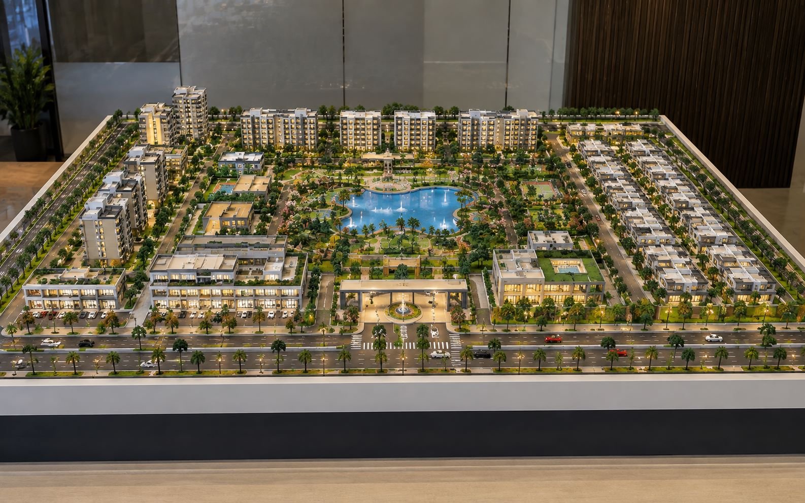
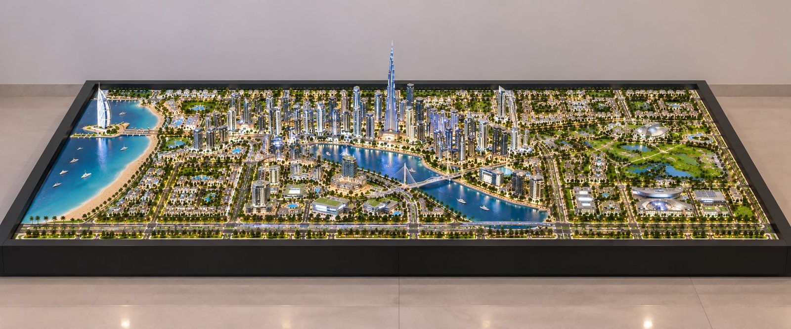
The featured model shows a large residential township on a broad rectangular base. Its wide and low-height design keeps the complete site visible. Residential towers, villas, roads, gardens, sports areas, water features and community spaces form a connected layout. Each part adds value to the overall township design.
A detailed township master plan model also helps architects, developers, planners and real estate teams understand the project. They can study the relationship between buildings, roads and open spaces before construction begins. The physical model turns a complex site plan into an easy-to-understand visual presentation.
Understanding the Residential Township Architectural Model
A residential township architectural model presents an entire residential development at a selected scale. A single building model focuses on one structure. A township model covers the complete site and its different zones.
The model can include apartment towers, villas, row houses and community buildings. It can also show commercial areas, parking zones, entrance gates and internal roads. Parks, gardens, pathways, sports facilities and water features can add further detail.
This approach suits large residential developments. Such projects need more than individual building details. The overall site planning also plays a major role.
Creating a Complete Township Layout
The featured model presents the township as one connected development. Taller residential towers create a strong visual presence around the site. Lower residential units fill other sections of the development.
The wide rectangular base gives enough space for roads and landscape areas. It also keeps the main features visible in a single view. This layout works well for a blog feature image and a real estate presentation.
A viewer can quickly identify the main residential zones. The road network also becomes easy to follow. Parks, amenities and green spaces add visual separation between building clusters.
Planning Roads in a Township Model
Road planning forms an important part of every residential township. Roads connect the entrance with homes, parking areas and community facilities. They also create clear movement routes across the development.
A physical architectural scale model can show this road network in three dimensions. The main approach road can have a wider layout. Secondary roads can connect different residential clusters. Smaller pathways can link parks, gardens and recreational areas.
Showing Internal Road Connections
The featured township model uses a structured road network across the site. A main road runs along the front edge of the development. Internal roads then move toward the residential areas.
Landscape elements line several road sections. Trees and planted areas create a defined streetscape. The road layout also connects the different parts of the township.
A township master plan model can show intersections, turning areas and access points. It can also display parking zones and pedestrian routes. An elevated view makes these connections easier to understand.
Developers can use this physical representation during site planning discussions. The road network remains visible beside buildings, parks and amenities.
Residential Buildings and Building Clusters
The arrangement of buildings gives a township its main architectural character. A residential development may include high-rise towers, mid-rise buildings or villas. Some projects may combine several housing types.
The featured model uses different building heights across the site. Tall residential towers create a clear skyline. Lower homes occupy central and surrounding areas.
This difference in height creates visual variety. It also helps viewers understand the scale of the proposed development.
Architectural Details in Residential Models
A residential project model can display many exterior features. These features may include building massing, façades, balconies and terraces. Roof profiles, windows and entrance areas can also appear in the model.
Larger scales allow more architectural details. Smaller scales focus more on building massing and site planning. The right scale depends on the project size and required detail.
Large township projects often need a scale that fits the full development onto one practical base. The model should remain easy to view while preserving important architectural features.
The purpose is not simply to make buildings smaller. The selected scale should present the complete project clearly.
Landscape Planning and Green Spaces
Landscape plays an important role in residential township planning. It connects buildings with roads and community spaces. Green areas also create visual balance across a large development.
A physical landscape architectural model can show trees, lawns, gardens and pathways. It can also include planting zones and recreational spaces.
The featured township model contains extensive greenery between residential buildings. Trees line important roads and pathways. Landscaped areas fill the spaces between building clusters.
Creating Green Zones Within the Township
Landscape planning can create different outdoor environments. Formal gardens can surround residential buildings. Larger green areas can become community parks. Pedestrian corridors can connect these spaces with nearby amenities.
These elements give the township a more complete visual character. They also help viewers understand the relationship between built and open areas.
For real estate presentations, landscape details can explain the planned outdoor environment. The physical model gives viewers a clear sense of how the site may feel after development.
Parks, Recreation and Community Amenities
A residential township usually includes more than housing. Shared amenities form an important part of the overall site plan. These spaces can support recreation and community activities.
The featured architectural model places recreational areas between residential zones. A landscaped central area contains a water feature. Sports facilities occupy another section of the site.
Clubhouse and Recreational Areas
A clubhouse can act as a major community feature within a township. Swimming pools can add another recreational element. Sports courts, children’s play areas and gardens can also form part of the design.
Jogging paths and gathering spaces can connect these facilities. Their placement helps explain how residents may move through the community.
The physical model therefore shows more than building locations. It presents the complete community structure in three dimensions.
A detailed township model can combine residential clusters, parks, roads and amenities. This makes the complete planning concept easier to understand.
The Importance of Scale in a Township Architectural Model
Scale controls the amount of detail that a physical model can show. A large building can display many façade features at a larger scale. An extensive township needs a smaller scale to fit the complete site.
A residential township architectural model therefore needs a careful balance. The model should show architectural details without losing overall site visibility.
Wide and Low-Height Model Presentation
The featured image uses a broad horizontal composition. This format keeps the complete township visible from left to right.
The model has a relatively low visual height. At the same time, it has considerable horizontal length. Roads, buildings and landscape zones remain easy to identify.
This style works particularly well for a blog feature image. It also suits presentations where viewers need to understand the complete master plan.
A wide master plan model can communicate relationships between different site areas. The viewer can study the entire development without focusing on only one building.
Physical Model Making and Material Selection
Professional architectural models use different materials for different components. The choice depends on the required scale, design and level of detail.
Common materials can include acrylic, MDF, PVC, foam board and resin. Model makers can also use 3D-printed components for custom architectural elements.
Selecting Materials for Different Components
Transparent or translucent acrylic can represent glazing and water features. Sheet materials can create building masses and façade elements. 3D printing can produce detailed or customized parts.
Every material should support the overall appearance of the model. Clean fabrication helps maintain accurate proportions.
Small details can make a major visual difference. Road markings, trees, vehicles and streetlights add scale to the development. Landscape edges and building windows can further improve clarity.
The featured model combines these details with greenery, roads, water features and lighting. The result looks like a detailed physical scale model rather than a basic conceptual block model.
Lighting in a Residential Township Model
Lighting can add another visual layer to an architectural model. LED systems can highlight buildings, entrance areas and roads. They can also bring attention to landscape zones and community facilities.
Using LED Lighting Effectively
Warm interior lighting can create a realistic residential appearance. Street lighting can define the road network. Feature lighting can highlight the entrance gate or clubhouse.
The lighting should support the architecture. Excessive lighting can hide important details. A balanced system keeps the physical model clear and attractive.
Illuminated scale models can work well in sales galleries and real estate presentations. They can create a strong visual display for a proposed residential development.
How a Township Model Helps Explain the Master Plan
A master plan contains a large amount of information. It can include residential zones, roads, open spaces and amenities. Parking areas and development phases may also appear in the plan.
A township master plan model brings these elements into one three-dimensional presentation.
Making Spatial Relationships Easier to Understand
Architects can use the model to review spatial relationships. Developers can use it during project presentations. Clients and investors can understand the overall site more easily.
The model can also represent different development phases. Building clusters, amenity zones and infrastructure areas can appear within the same physical site.
This approach gives viewers a spatial understanding of the project. They can study the development without moving between multiple two-dimensional drawings.
Residential Township Model for Real Estate Presentation
Real estate developers often need to present a project before construction finishes. A real estate scale model can become an important part of that presentation.
The physical model can display buildings, roads, entrance areas, landscape and amenities together. Visitors can therefore see the complete development before visiting the actual site.
Using the Model With Other Marketing Materials
A residential model can work alongside brochures and digital screens. Floor plans and architectural renders can also support the presentation.
The physical model offers a different experience. Viewers can study the development from several angles. They can also understand the relationship between different areas.
This becomes especially useful for large township projects. The complete site remains visible in one coordinated presentation.
Architectural Detail and Visual Clarity
The quality of a township architectural model depends on both detail and clarity. Buildings should maintain consistent proportions. Roads should remain easy to identify. Landscape should support the architecture instead of hiding it.
Amenities should also remain visually distinct from nearby areas.
Creating a Clear Physical Model Photograph
The featured model uses a balanced distribution of buildings and open areas. Residential towers create the main visual focus. Lower buildings, roads and greenery provide supporting detail.
The wide composition also suits a blog feature image. Viewers can identify the subject as a residential township immediately.
A clear model photograph needs controlled lighting and sharp focus. A clean background can reduce distractions. An elevated viewing angle can reveal more of the site.
These elements help present the physical model in a professional way.
Role of Architectural Model Making in Project Visualization
Architectural model making connects drawings with physical space. CAD drawings provide technical information. Digital visualization creates a rendered view of the proposed design.
A physical architectural model adds another form of communication. It allows viewers to study the project as a tangible object.
Visualizing Interconnected Township Elements
A residential township contains many connected elements. High-rise buildings may sit near villas and community spaces. Roads may connect several residential sectors. Parks may sit between building clusters.
The model can show all these relationships together. It can also show how amenities fit within the site boundary.
This makes architectural scale models useful for design presentations and real estate developments. They also support project discussions and large-scale master planning.
Designing a Balanced Residential Township
Good township planning requires balance between buildings, roads, landscape and community facilities. A physical model can make this balance easier to see.
Residential blocks should create an organized site layout. Roads should provide clear access across the development. Parks and open spaces can create separation between building clusters.
Community facilities should also have suitable connections with residential areas.
Creating a Connected Community Layout
The featured model combines high-rise buildings with lower residential units. Landscaped areas fill spaces between these zones. Roads connect the different sections of the development.
Sports facilities and water features add recreational value. Community spaces create additional points of interaction.
These elements work together to present the township as one connected environment.
Why Detailed Township Models Matter
A detailed township model can communicate information that may take longer to understand from a single drawing. The physical representation shows scale, density and spatial relationships together.
Architects, developers, planners and consultants can review the same physical model. This can make discussions about building placement and road connectivity more visual.
Open spaces and amenities also become easier to discuss.
A Physical Tool for Project Communication
The model works as both a presentation object and a communication tool. It provides a complete view of the proposed development.
For a large residential project, this ability can be valuable. The entire development appears within one coordinated physical representation.
Residential Township Architectural Model as a Complete Visual Story
The featured model tells the story of the township through one wide view. The main road and entrance establish the primary access point at the front.
Residential buildings and lower housing clusters create the main living zones. Parks and water features add shared outdoor spaces.
Recreational facilities and community areas complete the site layout.
Connecting Architecture, Roads and Landscape
Trees and planted areas connect the different zones. Internal roads create continuous movement through the township.
This composition shows the difference between a township model and a single building model. The focus does not remain on one structure.
Instead, the model shows the relationship between architecture, infrastructure and landscape.
Final Thoughts
A Residential Township Architectural Model provides a clear physical representation of roads, buildings, landscapes and community amenities. The featured model uses a wide and low-height format. This keeps the complete site visible while preserving important architectural details.
Residential towers and villas form the main housing areas. Internal roads connect the different zones. Parks, water features and sports facilities add recreational spaces. Pathways and community areas complete the planned environment.
For architects, developers, planners and real estate professionals, a detailed township master plan model can turn a complex site plan into a clear three-dimensional presentation.
The physical model helps viewers understand the project as one complete environment. It connects architectural design with roads, landscape and community facilities.
Residential developments continue to include more detailed planning and larger integrated spaces. Physical architectural scale models can help communicate these concepts in a direct and visual way.
A carefully crafted township model does more than show the future appearance of a development. It explains how buildings, roads, landscapes and shared spaces work together within the planned community.