Detailed Expressway Scale Models for Modern Road Development
Introduction to Expressway Development Scale Model
An Expressway Development Scale Model provides a detailed physical representation of modern highway and transportation infrastructure. Expressways connect major cities, industrial areas, commercial centres, airports, and important transportation hubs. Therefore, infrastructure developers and government authorities use detailed planning methods to present these large transportation projects.
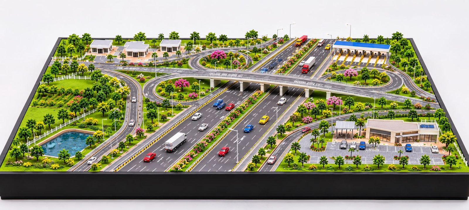
Modern expressway projects involve several important components, including multi-lane highways, flyovers, bridges, road interchanges, toll plazas, service roads, underpasses, drainage systems, and landscape development. However, explaining all these components through technical drawings alone can sometimes become difficult. A physical scale model makes the complete infrastructure layout easier to understand.
Moreover, a professionally developed expressway model transforms engineering drawings and planning concepts into a realistic three-dimensional presentation. It allows viewers to examine the main highway alignment, connecting roads, elevated structures, traffic arrangements, and surrounding landscape from different viewing angles.
Infrastructure consultants, highway engineering companies, government departments, construction firms, and urban planners can use these models during project presentations and development discussions.
At PAL Design Models, custom physical model making focuses on representing architectural and engineering concepts through detailed miniature structures. Each project can follow its original drawings, selected scale, dimensions, and presentation requirements.
What Is an Expressway Development Scale Model?
An Expressway Development Scale Model is a physical miniature representation of a proposed or existing expressway project. It shows the road network, transportation facilities, connecting infrastructure, and surrounding development in a reduced size.
The model helps viewers understand how different parts of a highway project connect with one another. For example, a large expressway development may include two main carriageways, multiple entry and exit ramps, elevated flyovers, bridges, toll collection facilities, and roadside service areas.
A three-dimensional model brings these elements together in one organised layout. Consequently, viewers can understand the complete project without studying several separate engineering drawings.
Depending on the project requirements, an expressway scale model may include:
- Multi-lane highways and main carriageways.
- Central road medians and traffic dividers.
- Elevated expressways and flyovers.
- Highway bridges and underpasses.
- Cloverleaf and directional interchanges.
- Entry and exit ramps.
- Toll plazas and collection booths.
- Service roads and connecting highways.
- Roadside parking and rest areas.
- Miniature cars, buses, and heavy vehicles.
- Streetlights and traffic signs.
- Green belts and landscape development.
- Drainage channels and water features.
- Supporting buildings and utility facilities.
Furthermore, the model maker can customise each element according to the available engineering drawings and project layout. This ensures that the final physical model reflects the actual infrastructure concept.
Importance of Expressway Scale Models in Infrastructure Projects
Expressway projects require careful coordination between several technical teams. Highway engineers, architects, transportation planners, structural consultants, landscape designers, and construction companies all contribute to the development process.
Each team works with different technical information. Consequently, project stakeholders may find it difficult to understand the complete development through separate drawings and documents.
A physical expressway model creates a common visual reference for everyone. Moreover, it helps different teams discuss the project using the same three-dimensional presentation.
Better Understanding of Expressway Layouts
A physical model presents the complete road arrangement in three dimensions. Viewers can clearly identify the main carriageway, service roads, connecting ramps, and elevated structures.
In addition, the model helps explain how vehicles move between different sections of the highway. This makes complicated road connections easier to understand.
Clear Presentation of Expressway Infrastructure
Modern expressways often contain complicated road junctions and multiple connecting routes. These arrangements can look confusing in a two-dimensional drawing.
However, a physical model shows the actual height differences and spatial relationships between road sections. As a result, viewers can understand the overall arrangement more easily.
Improved Project Communication
Project presentations often involve government authorities, investors, consultants, contractors, and development partners.
A detailed physical model helps project teams explain important infrastructure features without relying entirely on technical terminology. Furthermore, stakeholders can examine the model from different directions and discuss specific project components.
Professional Infrastructure Presentation
A well-designed expressway model adds visual value to project meetings, exhibitions, and corporate presentations.
Moreover, it helps developers present their infrastructure proposals in a structured and professional manner. A realistic physical representation can also make the main project features easier to remember.
Major Components of an Expressway Development Scale Model
Every expressway project has its own engineering requirements. Therefore, the model should represent the main infrastructure components according to the actual project design.
Main Expressway Carriageway
The main carriageway forms the central part of an expressway development. It carries high-speed traffic and connects different destinations along the transportation corridor.
A detailed physical model should clearly show the number of lanes, central median, road shoulders, lane markings, and safety barriers.
The road surface generally uses a grey or dark asphalt finish to create a realistic appearance. In addition, miniature vehicles help demonstrate the scale and traffic arrangement of the expressway.
Multi-Lane Expressway Road Detailing
Modern expressways may contain four, six, eight, or more traffic lanes depending on their design capacity.
The model should maintain proper lane widths and road alignment. Furthermore, white lane markings, edge lines, and central dividers help distinguish individual road sections.
Expressway Highway Interchanges
Interchanges connect different highways and allow vehicles to change directions through dedicated ramps.
They play an important role in maintaining smooth traffic movement and reducing interruptions at major junctions. Therefore, accurate interchange detailing is essential in an expressway physical model.
A professionally detailed model can include several interchange configurations.
Cloverleaf Interchange
A cloverleaf interchange uses curved loop ramps to connect different road directions. Its layout creates a recognisable pattern with multiple curved sections.
The physical model should show the correct ramp arrangement and elevation differences. Additionally, proper road markings can improve the visual understanding of traffic movement.
Trumpet Interchange
A trumpet interchange generally connects one major highway with another road. It uses a combination of curved ramps and merging lanes.
This arrangement works well for specific highway junctions and connecting corridors. Therefore, the model should follow the actual interchange design.
Diamond Interchange
A diamond interchange connects a highway with a secondary road through a compact arrangement of ramps.
The model can clearly show the relationship between the main road and the connecting route. Moreover, it can demonstrate the position of the junction and surrounding road connections.
Directional Interchange
Directional interchanges support traffic movement between major highway corridors. They often use elevated ramps and larger connecting structures.
These features require careful three-dimensional detailing to represent their actual configuration. In addition, different road levels should remain clearly visible from the main viewing angles.
Expressway Flyovers and Elevated Roads
Flyovers allow vehicles to cross existing roads, railway lines, and other transportation corridors without interrupting traffic movement.
A physical model can represent these structures through elevated road decks, concrete support piers, parapet walls, and connecting ramps.
The model maker should maintain the correct height and alignment of each structure according to the engineering drawings. Furthermore, realistic road markings and miniature vehicles improve the overall presentation.
Expressway Bridge Structures
Expressway corridors sometimes cross rivers, canals, valleys, railway tracks, and other geographical obstacles.
Therefore, bridges form an important part of many highway development projects.
Depending on the original design, a model can include:
- Reinforced concrete bridges.
- Steel girder bridges.
- Precast segmental bridges.
- Cable-stayed bridges.
- Suspension bridges.
- River crossing structures.
- Elevated bridge approaches.
Bridge decks, supporting piers, parapet walls, and approach roads create a more complete physical representation. Additionally, suitable materials help reproduce the appearance of different bridge structures.
Expressway Toll Plaza Development
Toll plazas provide facilities for toll collection and traffic management along expressway corridors.
A detailed toll plaza model can include multiple toll lanes, collection booths, canopy structures, traffic barriers, lane dividers, and electronic toll collection equipment.
In addition, direction signs and miniature vehicles can demonstrate how traffic enters and passes through the toll facility. The arrangement should follow the actual project layout.
Expressway Service Roads and Connecting Routes
Service roads connect nearby residential areas, commercial developments, industrial zones, and local transportation networks with the main expressway.
They also provide access to roadside facilities and selected connecting roads.
A physical model should clearly distinguish service roads from the main carriageway through road width, surface markings, and surrounding landscape features. Consequently, viewers can identify the different road networks without confusion.
Landscape Development in Expressway Scale Models
Landscape development improves the visual appearance of an expressway project. At the same time, it helps explain the environmental planning around the transportation corridor.
A professionally developed model can include roadside plantation, green medians, gardens, water bodies, and landscaped service areas.
Green Medians and Roadside Plantation
Green medians separate opposing traffic directions and provide space for grass, shrubs, and decorative plantation.
Similarly, roadside plantation can extend along the expressway boundary. Miniature trees, bushes, flowers, and grass materials help create realistic landscape detailing.
Expressway Green Belts
Green belts provide landscaped buffer areas along transportation corridors.
They may include rows of trees, shrubs, grass-covered spaces, and selected plantation zones. Therefore, the physical model should represent these areas according to the original landscape plan.
Highway Rest Areas
Rest areas provide important facilities for drivers and passengers during long-distance journeys.
These locations may include parking spaces, restaurants, restrooms, fuel stations, seating areas, and landscaped gardens.
A scale model can represent these facilities through miniature buildings and organised parking layouts. Moreover, the surrounding plantation can improve the overall presentation.
Water Bodies and Drainage Systems
Some expressway projects include ponds, canals, drainage channels, and stormwater management facilities.
These elements help explain how the project manages surrounding water resources. For example, transparent acrylic and suitable textured materials can represent water surfaces within the model.
In addition, drainage channels can be positioned alongside the road according to the project drawings.
Different Types of Expressway Development Models
Expressway projects differ according to their location, engineering requirements, and transportation objectives. Therefore, model makers can develop different physical model configurations for individual projects.
Greenfield Expressway Scale Model
A Greenfield Expressway represents a newly planned road corridor developed along a new alignment.
The model may include long highway sections, bridges, flyovers, interchanges, toll plazas, service roads, and surrounding landscape.
These models help developers explain the complete transportation corridor and its proposed infrastructure. Furthermore, they provide a clear view of the relationship between different road sections.
Elevated Expressway Development Model
An elevated expressway carries traffic above existing ground-level roads or developed areas.
Its model may include concrete piers, elevated road decks, entry ramps, exit ramps, and ground-level transportation facilities.
In addition, the model can show nearby buildings and existing roads to explain the relationship between the new structure and its surroundings.
Urban Expressway Development Model
Urban expressways connect important areas within and around major cities.
These projects may include elevated corridors, underpasses, flyovers, service roads, commercial developments, and residential areas.
A physical model can demonstrate how the proposed highway connects different parts of an urban region. Moreover, it can show the surrounding land use and supporting infrastructure.
Ring Road Expressway Model
A ring road provides an alternative transportation route around a city or urban development.
Its layout may include several junctions, radial road connections, bridges, and interchange structures.
A master plan model helps viewers understand how the ring road connects different city sectors. Consequently, it becomes easier to explain the wider transportation network.
Highway Expansion and Widening Model
Highway expansion projects increase the capacity of existing transportation corridors.
They may include additional lanes, wider medians, improved junctions, new flyovers, and upgraded bridges.
A physical model can demonstrate the proposed changes alongside existing infrastructure. This also helps project teams present the planned improvements more clearly.
Coastal Expressway Development Model
Coastal expressways connect destinations near coastal regions.
These projects may include sea-facing roads, bridges, coastal protection structures, drainage systems, and landscape development.
The model can also represent nearby settlements and supporting transportation facilities. Additionally, suitable terrain and water detailing can improve the presentation.
Mountain Expressway Development Model
Mountain expressways require special road arrangements because of uneven terrain and elevation changes.
Their models may include curved highways, tunnels, retaining walls, bridges, slope protection systems, and elevated road sections.
Terrain detailing plays an important role in presenting these projects accurately. Therefore, the model should represent the surrounding land levels and road alignment carefully.
Materials Used for Expressway Physical Model Making
Material selection directly affects the appearance, strength, and detailing of an expressway scale model.
Different materials serve different purposes. Therefore, the model maker should select suitable materials according to the scale, project dimensions, and manufacturing requirements.
Acrylic Sheets
Acrylic sheets work well for transparent structures, selected miniature components, protective covers, and water features.
They offer a smooth finish and allow precise cutting into different shapes. Moreover, transparent acrylic can create clean and professional display elements.
MDF and Wooden Materials
MDF and wooden sheets provide a stable foundation for the model.
They are commonly useful for baseboards, supporting platforms, and selected structural components. A properly finished rectangular baseboard also improves the overall presentation.
Foam Board and PVC Sheets
Foam board and PVC sheets offer lightweight options for road platforms, supporting structures, landscape levels, and architectural elements.
Moreover, these materials allow the model maker to develop different shapes according to the project requirements.
3D Printed Components
3D printing supports the manufacturing of complex miniature components.
For example, model makers can create custom bridge supports, toll booths, structural details, road barriers, and selected architectural elements.
This process also helps produce consistent shapes and detailed components. Additionally, it supports the development of project-specific structures that may be difficult to manufacture through conventional methods.
Miniature Landscaping Materials
Miniature trees, shrubs, grass materials, stones, and decorative plants help develop realistic landscape arrangements.
Their placement should follow the actual landscape design whenever project drawings provide that information. Similarly, suitable colour combinations can help distinguish different landscape zones.
LED Lighting Components
LED lighting can highlight selected road sections, bridges, toll plazas, buildings, and streetlights.
Furthermore, carefully positioned lighting can improve the appearance of the model during indoor presentations and exhibitions. However, lighting should remain balanced so that it does not hide important physical details.
Role of CAD Drawings and 3D Design in Expressway Model Making
CAD drawings and three-dimensional design files provide important references for manufacturing an accurate expressway model.
Large infrastructure projects contain detailed information about road alignment, lane widths, elevations, interchange geometry, bridge positions, and surrounding development.
Using these references helps the model maker maintain consistency between the original design and the final physical model. In addition, digital planning helps organise the manufacturing work.
Reviewing Expressway Engineering Drawings
The model development process begins with a review of the available project information.
Important reference documents may include:
- General arrangement drawings.
- Highway alignment plans.
- Road cross-section drawings.
- Interchange layout drawings.
- Bridge and flyover drawings.
- Landscape development plans.
- Topographical site plans.
- Supporting infrastructure layouts.
These documents help identify the position, dimensions, and arrangement of individual model components.
CAD-Based Layout Development
CAD drawings help establish road geometry, carriageway widths, interchange arrangements, and structural positions.
They also provide a useful reference for preparing the model layout. Consequently, the manufacturing team can follow a more organised approach.
Three-Dimensional Modelling
Three-dimensional design software helps visualise complex road structures before physical manufacturing begins.
It also allows the team to examine elevation differences, connecting ramps, bridge arrangements, and surrounding structures. Furthermore, the digital model can help identify design relationships that may need attention during physical production.
Scale Conversion and Accuracy
Scale selection is an important part of physical model making.
The selected scale should maintain consistent proportions across all major components.
For example, at a 1:1000 scale, one metre of actual length equals one millimetre in the model.
Similarly, at a 1:500 scale, one metre of actual length equals two millimetres in the model.
Therefore, the model maker should select a suitable scale according to the project dimensions, available display area, and required level of detailing.
Customisation Options for Expressway Development Scale Models
Every infrastructure project has different presentation requirements. A custom model can follow the project’s drawings, selected materials, display dimensions, and desired detailing.
Custom Rectangular Baseboard
The baseboard supports the complete model and provides a stable presentation platform.
Its dimensions should match the overall project layout. A professional baseboard generally features straight edges, a clean rectangular shape, consistent thickness, and a smooth finish.
Moreover, the model should sit evenly on the platform without unnecessary raised or uneven sections. A clean baseboard also helps maintain a professional appearance.
Project-Specific Expressway Road Layout
The road layout can follow the actual highway alignment and engineering drawings.
The model maker can customise the number of lanes, road medians, connecting ramps, flyovers, and service roads. In addition, the layout can include the surrounding infrastructure shown in the project plan.
Miniature Vehicles and Traffic Elements
Miniature cars, buses, trucks, and other vehicles add scale and realism to the model.
Similarly, road signs, barriers, traffic signals, and streetlights improve the overall detailing.
Supporting Buildings and Facilities
The model can include toll administration buildings, maintenance facilities, rest areas, parking structures, and other supporting infrastructure.
Their design and placement should match the project layout. Furthermore, miniature landscape elements can complete the surrounding presentation.
Lighting and Protective Enclosures
Optional LED lighting can highlight selected infrastructure features.
In addition, a transparent protective enclosure can help protect the finished model from dust and physical contact.
Applications of Expressway Development Scale Models
Physical expressway models serve several purposes across infrastructure planning, engineering, construction, and project presentation.
Government Infrastructure Presentations
Government departments and infrastructure authorities can use physical models to explain proposed highway developments.
The model helps officials understand the main road alignment, connecting infrastructure, and supporting facilities. Moreover, it creates a clear visual reference during project discussions.
Highway Engineering Companies
Highway engineering consultants can present road layouts, bridge positions, interchange designs, and other infrastructure components through detailed physical models.
As a result, technical teams can explain their proposed arrangements more effectively.
Infrastructure Project Developers
Infrastructure developers can use these models during presentations to investors, partners, and project stakeholders.
Furthermore, the model helps communicate the complete development concept in a single display.
Construction and EPC Companies
Construction and EPC companies can use scale models to explain project scope and major infrastructure components.
They can also use the model during technical meetings and project reviews. In addition, it can help different teams discuss the planned construction arrangement.
Urban Planning and Development Projects
Urban planners can demonstrate how expressways connect residential townships, commercial centres, industrial areas, and other important developments.
This approach helps explain the relationship between transportation infrastructure and regional planning. Consequently, viewers can understand the wider development context.
Infrastructure Exhibitions and Trade Shows
Physical models attract attention at infrastructure exhibitions, engineering events, and corporate showcases.
A detailed expressway model gives visitors a clear view of the proposed project and its major components. Moreover, it creates an effective display for explaining complex infrastructure concepts.
Educational and Technical Demonstrations
Engineering colleges and technical institutions can use expressway models to explain highway planning, road geometry, bridge structures, and transportation systems.
Similarly, these models can support technical presentations and practical learning activities.
Benefits of Using an Expressway Physical Scale Model
A physical model offers several advantages when presenting complex infrastructure projects.
Better Three-Dimensional Understanding
Viewers can examine the highway layout from different directions.
For example, they can observe elevated roads, ground-level highways, connecting ramps, and surrounding development within the same display. This makes the complete project easier to understand.
Clear Visual Communication
A model presents multiple infrastructure elements together.
Therefore, project teams can explain important details without depending entirely on technical drawings. In addition, viewers can identify different road sections through their physical arrangement.
Improved Project Presentation
A professional physical model creates a clear and organised presentation.
It also helps developers communicate their proposals during client meetings and stakeholder discussions. Furthermore, detailed physical structures can make important project features easier to recognise.
Better Understanding of Surrounding Development
The model can include nearby buildings, industrial areas, residential developments, green spaces, and other supporting facilities.
As a result, viewers can understand how the expressway fits into the larger development plan.
Long-Term Display Value
A professionally manufactured model can serve as a long-term presentation and reference tool.
Companies can display it in project offices, corporate facilities, engineering centres, and exhibition spaces. Moreover, the physical model can support future project discussions.
Factors to Consider Before Ordering an Expressway Scale Model
Before starting the manufacturing process, project teams should review several important requirements.
Overall Project Dimensions
The total length and width of the proposed highway corridor help determine the model size.
Large projects may require a wider baseboard or multiple connected display sections. Therefore, the available display space should be considered before selecting the final dimensions.
Selection of Scale
The selected scale should balance the overall project size with the required level of detailing.
A smaller scale can represent a longer highway corridor, while a larger scale can provide more visible detail for individual structures. Consequently, the scale should match the purpose of the model.
Availability of Engineering Drawings
Accurate drawings help the model maker understand the actual project arrangement.
CAD files, PDF layouts, site plans, and 3D design files can all support the development process. In addition, updated drawings help maintain consistency during manufacturing.
Required Level of Detailing
Some projects require only the main road alignment and interchange layout.
However, other projects may need detailed bridge structures, toll facilities, miniature vehicles, buildings, landscaping, and lighting. Therefore, teams should discuss the required detailing before manufacturing begins.
Display Location and Baseboard Design
The final model dimensions should match the available display space.
Teams should also consider baseboard finishing, lighting, protective covers, and viewing arrangements. Moreover, a stable rectangular baseboard helps present the complete infrastructure layout neatly.
Budget and Project Timeline
Material selection, scale, model dimensions, and detailing requirements influence the overall manufacturing cost and production time.
A clear project brief helps establish practical expectations before production starts. Furthermore, early planning allows the team to organise materials and manufacturing requirements.
Professional Expressway Model Making Services by PAL Design Models
PAL Design Models offers custom physical model making solutions for architectural, industrial, engineering, and infrastructure presentation projects.
Expressway projects require careful interpretation of technical drawings and accurate representation of different transportation components. Therefore, the model making process should focus on both engineering details and professional physical presentation.
Our model making solutions can support different highway and infrastructure requirements according to the available project information.
Custom Highway and Expressway Models
Custom models can represent multi-lane highways, elevated roads, flyovers, bridges, interchanges, toll plazas, and connecting roads.
The complete layout can follow the available engineering drawings and project dimensions. Moreover, project-specific components can be manufactured according to the required scale.
Infrastructure and Engineering Models
Infrastructure models can represent transportation corridors, structural arrangements, bridge systems, and supporting facilities.
These models help present technical concepts through physical miniature structures. In addition, they provide a common visual reference for project teams.
Architectural and Landscape Detailing
The surrounding development can include buildings, roadside plantation, green spaces, parking areas, and other landscape elements.
Each component can follow the project layout and presentation requirements. Furthermore, suitable colours and surface finishes can improve the visual quality of the model.
3D Printing and Laser Cutting Services
Modern manufacturing techniques such as 3D printing and laser cutting support the production of selected miniature structures and custom components.
These techniques help create precise shapes and consistent detailing. Consequently, they are useful for manufacturing complex project-specific elements.
Custom Project Development
Every project can follow its own dimensions, selected scale, material preferences, drawings, and display requirements.
From a small highway presentation model to a large infrastructure development model, the design can match the intended purpose.
To explore architectural, industrial, engineering, and infrastructure model making services, visit the official website:
Future of Expressway Development and Infrastructure Model Making
Transportation infrastructure continues to develop with improvements in engineering, construction technology, and urban planning.
Modern expressways increasingly incorporate intelligent transportation systems, electronic toll collection, advanced traffic monitoring, sustainable drainage, and environmentally responsible landscape development.
Physical models can represent these features and explain how they work together within a larger transportation network. Furthermore, they can present future infrastructure concepts in a clear physical format.
Smart Expressway Infrastructure
Smart expressways use modern systems to improve traffic management and transportation efficiency.
These systems may include electronic toll collection, traffic monitoring equipment, variable message signs, surveillance facilities, and connected transportation technology.
A physical model can represent selected components through miniature structures and visual details. In addition, it can show where different facilities connect with the main highway.
Sustainable Expressway Development
Sustainable expressway planning focuses on environmental protection, efficient land use, and responsible resource management.
For example, projects may include roadside plantation, green belts, rainwater management, and landscaped buffer zones.
A detailed scale model can present these features alongside the main transportation infrastructure. Consequently, viewers can understand both the road development and its surrounding environmental planning.
Advanced Expressway Interchange Planning
Growing traffic volumes require efficient interchange arrangements.
Future projects may include complex directional ramps, elevated connections, and improved highway junctions.
Three-dimensional physical models help explain these structures and their relationship with surrounding roads. Moreover, they allow viewers to examine different road levels in one display.
Integration with Smart Cities
Expressways connect important urban and regional development zones.
These may include residential townships, commercial districts, industrial parks, logistics hubs, and airport developments.
An integrated infrastructure model can show how the transportation corridor supports connectivity between these different areas. As a result, it provides a wider understanding of the proposed development.
Conclusion
An Expressway Development Scale Model provides an effective way to present modern highway and transportation infrastructure through a detailed three-dimensional physical representation.
From multi-lane expressways and elevated flyovers to bridges, interchanges, toll plazas, service roads, and landscape development, every component contributes to the overall project presentation.
A professionally developed model helps viewers understand complex road arrangements and the relationship between different infrastructure elements. Furthermore, accurate scale conversion, suitable material selection, detailed road markings, realistic miniature structures, and a properly finished rectangular baseboard all contribute to the quality of the final model.
PAL Design Models provides custom physical model making solutions for architectural, industrial, engineering, and infrastructure projects. Each model can follow the available technical drawings, project dimensions, selected scale, and presentation requirements.
Whether the project involves a greenfield expressway, urban highway corridor, elevated expressway, ring road, or integrated transportation development, a carefully designed physical scale model can turn complex engineering information into a clear and professional presentation.